HOW TO PLAN A PHOTOGRAPHIC TRIP & FIND SPOTS
The first time I went on a photographic trip I was very excited and eager to see absolutely all the places I had been selecting from the tourism pages. I got there, had a great time but on my return I had to admit to myself that nothing had turned out as I had planned in my mind, that I had come back with far fewer photographs than I had expected and that most of them were not well polished in terms of perspective.
Has this ever happened to you? Don't worry, it's completely normal and unless you have several months to explore the area in situ, you're unlikely to see everything you set out to see and get the shots you had imagined.
When we plan a trip in terms of photography, we have to be aware that the best way to find the perspective we have in mind is to dedicate a reasonable amount of time to each place, but is there anything we can do beforehand to make our task easier? Yes, there is! :D These are the steps I follow when planning my trips, from a photographic point of view:
1.Reserch of the most touristic places you want to see and photograph.
This information can be found quite easily through Google by consulting tourism websites and travel blogs.
With this step what I'm looking for is to locate those areas that I already know from having seen them comfortably from the sofa at home on TV or on social networks.

Source: Google Search
2. Instagram
Thanks to hashtags and tourism pages that repost the work of photographers and travellers, this is a very powerful tool for finding locations that someone has already discovered. The biggest handicap is that in most cases the specific location does not appear, so we will have to later make a study on google maps to locate the exact location and this does not always work out well. The difficulty of finding the spot we have discovered on IG lies in the information we can extract from the post. The more information we can obtain on location, hashtags, comments... the easier it will be to find it.


Source: Instagram hashtags section / Instagram @ca_maraphy profile
3. MAPIFY
It's a great tool and it has helped me a lot to simplify the task of searching for spots! You can find specific spots by country and within each country by area. The interface is very intuitive and from it you will get the specific spot and the address. In addition, you can see the locations directly on google maps, which is amazing.
This app is based on sharing so it is very interesting that you become part of the community by uploading spots that you have visited and you have loved, so that anyone who accesses that destination, can have things as easy as you.


Source: Mapify app. Available in mobile stores.
4. Google Maps to explore areas and access roads.
This is my favorite part, from here on we become Sherlocks, and I will use google maps for mainly two steps:
- Create your personal map with the coordinates you find and the spots.
Creating your personal map, is a huge advantage, as we will have the locations by destination all collected in the same place where a couple of clicks, the GPS will be activated and will leave us right at the point that we have marked.
- Finding places that are not so popular but that I believe may have potential when it comes to photographing an area from different perspectives.
This step consists of combing the areas we are going to visit and those nearby with the street view tool, whenever possible. This is probably the longest and most tedious step of all as it requires a lot of time. Together with the IG reference photos, we will be able to try to locate all the spots we had pending to get a location and, in addition, in the exhaustive search we will find new spots that perhaps are not even photographed and we want to discover.


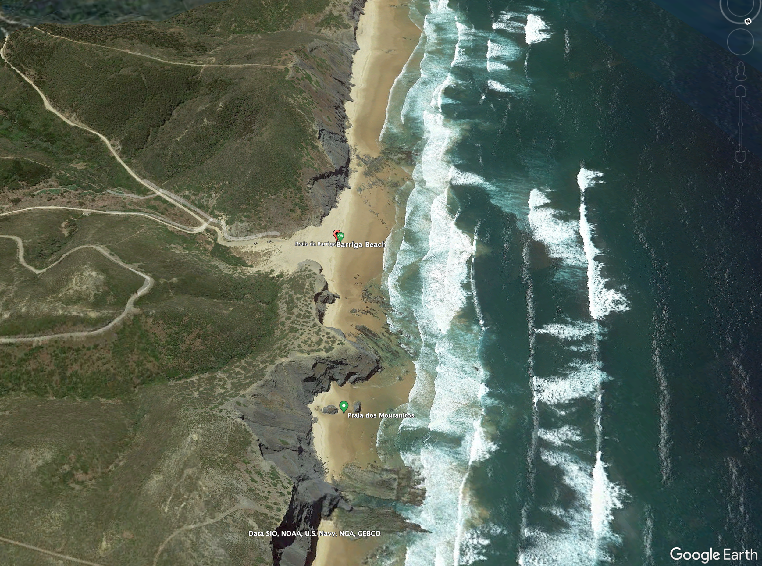
Screenshots from Google Maps mobile version. Same tools are available in desktop mode.
5. Google Earth for drones.
Blessed 3D view of Google Earth! You don't know how many drone batteries I've saved since I discovered this tool.
The 3D view allows us to see the terrain mapping, approximate altitudes thanks to its scale, and the 3D view.
- It is important to check the regulations of each country and local restrictions of each destination.
- Not all areas are always available in Google Earth with 3D view, so if we don't find them, the drone work in this expedition will be a bit complicated and we will have to leave it for the moment when we are there.

6. Talk to other photographers who have already been there.
Nowadays we are interconnected with anyone in a matter of seconds so this is something we should take advantage of. Surely you have friends, acquaintances or photographers to ask and ask for an opinion about a particular place, a tip that might come in handy or a spot that you discovered on your trip and you want to visit.
Exchanging opinions and experiences is one of the best ways to conclude our search, not only can we have a first hand opinion but also you will find a lot of people and acquaintances with similar hobbies to yours and that you didn't know!
7. QUICK GUIDE ON PDF OR NOTION.
I usually do it in Notion, which is a daily task planner and database that you can create as you wish, although it is just as valid to use a Word document, pages and transform it into PDF. The important thing here is not the platform or format we use, but rather that we record our planning offline. It is very important that we can access it without an internet connection because anywhere, especially when we are exploring, we can lose coverage.
I usually plan everything based on a location at dawn and another at dusk, knowing that the light I like the most is usually until 11am and from 16-17pm (of course this varies depending on the area of the world where you are) and, based on this, I make a daily schedule of the spots I want to see. I put a lot more than I'm actually going to be able to visit along with some plans I have in mind to make and some pictures I've found during my search for inspiration.
This way, at a glance I'll know where I am, where I'm going and what I was planning to do. As you can imagine, after such dense research, I no longer remember the first places I wanted to photograph so it helps me a lot to recapitulate and always have it at hand.
Which is the method you follow to find cool spots and plan your trips beforehand? Didi you discover some new way that you will apply?
AUTOR:

MARA DE LA TORRE
Professional travel & commercial photographer. Content creator. Spesialised in storytelling.
Lover of nature and capturing it through the lens.
FOLLOW ME IN SOCIAL MEDIA:
YOU MAY ALSO BE INTERESTED IN....